New York State Historic Archaeological Site Inventory Form
|
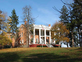
New York State Historic NYS OFFICE OF PARKS, RECREATION & HISTORIC PRESERVATION (518) 237-8643 For Office Use Only–Site Identifier Project Identifier USN A09303.000240 Your Name Louise Basa and John Wolcott Date September 1, 2006 Address Basa: 1220 Waverly Place, Schenectady, New York 12308 Phone (518 ) 377-4389 Organization (if any) 1. SITE IDENTIFIER(S) Stanford Mansion Archaeological Site (see supplemental pages for other names by which the site is known) 2. COUNTY Schenectady One of the following: CITY TOWNSHIP Niskayuna INCORPORATED VILLAGE UNINCORPORATED VILLAGE OR HAMLET 3. PRESENT OWNER Ingersoll Residence Address 3421 State Street, Niskayuna, New York 12304 4. SITE DESCRIPTION (check all appropriate categories):Structure/site See supplemental pages Superstructure: complete X partial collapsed not evident Foundation: above x below (ground level) not evident x Structural subdivisions apparent Only surface traces visible Buried traces detected List construction materials (be as specific as possible):brick, wood, stone Grounds Under cultivation Sustaining erosion Woodland x Upland Never cultivated x Previously cultivated Floodplain x Pastureland Soil Drainage: excellent good fair x poor Distance to nearest water from structure (approx.) Elevation: 411 ft. amsl 5. Site Investigation (append additional sheets, if necessary): none to date Surface — date (s) Site map (submit with form*) Collection Subsurface — date(s) Testing: shovel coring other unit size no. units (Submit plan of units with form*) Excavation: unit size no. of units (Submit plan of units with form*) * Submission should be 8 ½" by 11", if feasible Investigator Manuscript or published report (s) (reference fully): Present repository of materials 6. Site inventory: a. Date constructed or occupation period date of construction or occupation period: 1762 to present b. Previous owners, if known: see supplemental pages c. Modifications, if known see supplemental pages (append additional sheets, if necessary) 7. Site documentation (append additional sheets, if necessary): see supplemental pages a. Historic map references 1) Name Date Source Present location of original, if known 2) Name Date Source Present location of original, if known b. Representation in existing photography: see supplemental pages 1) Photo date Where located 2) Photo date Where located c. Primary and secondary source of documentation (reference fully): See supplemental pages d. Persons with memory of site: see supplemental pages 1) Name Address 2) Name Address 8. List of material remains other than those used in construction (be as specific as possible in identifying object and material): see supplemental pages If prehistoric materials are evident, check here and fill out prehistoric site form. No 9. Map References: Map or maps showing exact location and extent of site must accompany this form and be identified by source and date. Keep this submission to 8½" x 11", if possible. USGS 71/2 Minute Series Quad. Name 1954 Schenectady Quad For Office Use Only–UTM Coordinates 10. Photography (optional for environmental impact survey): Please submit a 5"x7" black and white print(s) showing the current state of the site. Provide a label for the print(s) on a separate sheet. See supplemental pages for descriptions NYS Historic Archaeological Site Inventory Form Supplemental pages Stanford Manor Archaeological Site (aka: Ingersoll Residence, Stanford Farm, Locust Grove, Stanford Mansion) Ref.: Ingersoll Historic Structure Report – OPRHP Project Id: 09303.000006 Item # 4: Site Description The following information describes the 19th c structure on the property that is currently occupied by the Ingersoll Residence (formerly the Ingersoll Memorial for Aged Men). The main house is the Stanford Mansion purchased and resized by NYS Senator Charles Stanford in 1865 (Munsell, 1885, p. 193) attaching narrow addition to the rear. Ingersoll Memorial purchased that structure from the Stanford heirs in the 1920s to use as a residence for the elderly. They did not alter this structure. In the 1930s, the Ingersoll Memorial attached a large addition to the rear of the existing historic building (see Item # 7 below). No further additions or modifications have been made. OPRHP Documents on File for the Structure, Project Id. 0903.000006: Attached to this Form are 4 historic structure forms that detail information on the 19th c Stanford structure. The most recent is by Ray Smith, 2006, in which he determined the property eligible for National and State Registers listing under Criteria A and C. The other attached documents are: a 1975 Historic Site Inventory Form and National Register forms with the name of Doris Manley upon the document, who was with the OPRHP staff, and a 1985 form from the Niskayuna survey submitted by Frank Taormine. Item # 6: Previous Owners In order of ownership from 1762 to the present: John Duncan, Richard Duncan, Harmanus P. Schuyler, his heirs, Lemuel Hand, John I. Vrooman, Josiah Stanford, NYS Senator Charles Stanford, his heirs, Ingersoll Memorial. Item # 7: Site Documentation 7a. Historic Maps and Surveys – Copies Attached 7a,1) 1771 J. Vrooman Survey Map Duncan’s house, the Hermitage and property on the "Schenectady Line" Reference: "A Tract of Land Granted by his Majesty’s Patent on the 17th of August 1730 to Arent Bardt and Jacob Glen in trust for the Dutch Church of Schenectady containing 2627 acres; Laid down from a scale of 20 chains to an inch; Surveyed at the request of the Minister, Elders and Deacons of the Dutch Church of Schenectady, January 29th 1771, by J. Vrooman." [Copy from John Wolcott] 7a, 2) 1893 USGS Topographic Map, Schenectady Quad: Two structures are located on the former Stanford Farm in 1893. One is the 19th c "Locust Grove" house and the other is a small structure on the Balltown Road property line. Topo maps typically show buildings but not barns. See Refer to the 1922-24 Plot Plan, the 1930 Randall map and the 1863 Topo below — the 400 ft contour interval and triangular intersection of Balltown Road and State Street provide easy recognition of the Stanford/Ingersoll property on the 1893 15 min. series since no labels mark the roads or houses on this older topo. 7a, 3) 1922-24 Plot Plan of the "Schenectady Home for Aged Men Known as the Ingersoll Memorial" (copied from an attachment to the 1975 OPRHP Structure’s Inventory Form): This plan outlines the size of the Ingersoll plot (12.5 acres) at "Stop 6" on the Albany Rd. (NYS Rt. 5) and provides dimensions of the lot in feet. The former Stanford Manor is in its historic and current place, centrally located on the lot with 3 interior roads to the house. The structures in the rear are in the same area as the "outbuildings" (stables and other uses) shown in a late 19th c. lithograph (see 7b below). Also, there is an L-shaped structure on the NW corner of the lot property line along Balltown Rd. This structure is in the same location as recorded on the 1893 Topo. See 1893 Topo above. 7a, 4) 1930 Randall Map of Schenectady (County Clerks Office) Historic Background on the Randall Survey: Detailed surveys for planning purposes were commissioned by Schenectady City/County in 1930. The resulting maps, surveyed by Randall are a major reference for the County’s topography in areas undeveloped at that time. In some areas (e.g.: in Scotia), a complete build-out was planned. Therefore, some of the streets illustrated are "paper streets" that were not built. Relevance to the Stanford property: Randall’s maps, in this section and many other survey areas, included only prominent landmark structures. Lot # 8 marks the Stanford/Ingersoll land and the landmark main house. Randall mapped the topography in 2 foot contour intervals, allowing us to measure the height of the top of the hill. The structure stands at 411 ft. amsl. See 1893 Topo above. 7a, 5) 1963 USGS Topographic Map, Schenectady Quad Geographical and Historical Background: The lower section of the distinctive triangle formed by the intersection of Balltown Road and State Street is included in the Township of Niskayuna, Schenectady County. In this area, part of the boundary between the town and the City of Schenectady is formed by the southern section of Balltown Road, with the notable inclusion of the Ingersoll Memorial land in Niskayuna. The Stanford’s residence in Niskayuna is commemorated on this topo in the names for a residential development, "Stanford Heights," and for the "Stanford Golf Course." The latter was formerly the location of NYS Senator Charles Stanford’s race course and is currently occupied by Mohawk Commons. These vestiges of the Stanford legacy in 20th c area reflect the impact of the family’s presence on the neighborhood. Elevation and Building: This map clearly shows no alteration in contour elevation since the survey for the 1893 Topo. The rise of ground on which the Stanford Mansion was built is prominently mentioned in the local history of 1885 (see quote from Munsell, below). The Randall map of 1930 (see 7a, 3 above) and photos (late 19th c and 2005, see 7b below) confirm the preservation of the hill and the open landscape around the building. On the 1963 Map: The building (black infill) is the Ingersoll Memorial Home with the 20th c extension in the rear that accommodated growth for its current use. 7b. Representation in existing Photographs and a Primary Source Lithograph: 7b, 1) A Lithograph of the "Residence of the Hon. Charles Stanford, Schenectady" (late 19th c.; exact date and other details of production unknown at this writing) illustrates the house, paths, barns/stables and treed, park-like landscape. The enlarged Victorian porch shown in the lithograph was later enlarged again (see 19th c Photo in 7b. 2 below). Source: A copy of the lithograph hangs in the front hall of the Ingersoll building. 7b, 2) Late 19th c/early 20th c. photo (Source: Tutorow (2004)) 7b, 3) 2005 Photos (Photo of Ingersoll building and grounds by Linda Champagne. Photos of side of structure by John Wolcott.)Comments: The 19th c narrow addition is visible in the rear of 7b, 1 & 2. In the 20th c., the Ingersoll enlargement was added onto this earlier addition. The 2005 photos of the main house (7b, 3) match the 19th c lithograph illustration of the same house (7b, 1) and show an identical façade to that in the earlier photo (7b, 2). 7c. Primary and Secondary Sources: See above under maps and photos for Primary Sources references for these documents. Also the SHPO Structures forms are listed under Item # 4. Publications: Tutorow, Norman E. The Governor – Life and Legacy of Leland Stanford. Spokane, Washington: The Arthur H. Clark Company, 2004 as cited in "Senator Charles Stanford (1819 – 1885): Schenectady Businessman, Statesman and Newspaper publisher" by Garrett Hermanson (Revised 8/05/06). Copies attached. Munsell, Rev. J.H. (edited and compiled): History of the County of Schenectady, 1662-1885. "History of the Township of Niskayuna" by the Rev. E.E. Taylor, pages 192-98. Quote from Munsell p. 193 (emphasis and reference to NYS Rt. 5 added) "John Duncan, a young Scotchman, with his wife, Martha March, came to Schenectady in 1755. He was possessed of a good capital, and opened a mercantile establishment on an improved scale and was very successful … He built a country seat called the Hermitage (that after his decease burned down) on his farm of 800 acres in the town of Niskayuna, a part of which is at present owned and occupied by ex-Senator Charles Stanford. The place is on the Schenectady-Albany turnpike [NYS Rt 5], about three miles from the City of Schenectady. At the Hermitage, Mr. Duncan died on May 5, 1791, aged 69 years, much esteemed for his generous hospitality and unostentatious benevolence. Shortly after the Hermitage was burned down, the place came into the hands of the Schulyers, who built a house on a rise of ground about one hundred yards north of the well where the Herimtage stood – the site of the Hermitage is distinctly marked by its old well that stood by the door, which the writer was shown while visiting the place. The Schuylers, after living here a number of years, sold the place to Captain Hand, and after a few years he sold the place to John I. Vrooman and he sold it to Josiah Sanford in March, 1859. Josiah Stanford died in 1861, and in 1865 Senator Charles Stanford, son of Josiah, brought the place of the heirs, rebuilt, enlarged and modernized the dwelling, and converted the place into a first-class stock farm. Mr. Stanford owns several valuable farms, and is largely connected with many leading enterprises in the City of Schenectady." 7 d. Persons with memories of the site: Helen Briggs, soon to be 95 on September 20, 2006, retains first hand recollections from the age of 11 of the property, as seen from the porch of her family’s house from across the Balltown Road, and to the east of the pasture lot (former Stanford racetrack.) At that time (1920s), Balltown Road was much narrower. She and her family could easily see the property and the dominate feature of towering pine trees, during and after the time changed hands from the Charles Stanford heirs to the Ingersoll Memorial. Helen Briggs currently resides at 1429 Garner Rd, Schenectady, NY 12309. Linda Champagne has interviewed her several times and intends to record her recollections Item # 8: List of material remains expected from the Historic Literature and archaeological experience with Historic sites Historic Sources: With few exceptions, the documents cited above are primary sources; that is, these are from contemporary surveys and personal accounts compiled during the period of known Euro-American occupation and use of the property (1762 to 2006). In summary, primary sources are: a) 1771 Vrooman survey with scale (John Duncan’s home, the Hermitage) b) 1885 first-hand report on the location of the Hermitage burned ruins by Rev Taylor (Munsell, 1885) who records the fact that the Hermitage well was 100 yards distant form the Stanford home. According to Hermanson (8/06), Josiah Stanford purchased the property and the 1814 federal style Schuyler residence on the hill in 1861. In 1865, Charles acquired his father house and property. c) 19th c lithograph (Charles Stanford Farm – "Locust Grove") d) Late 19th – early 20th c photo (Stanford Mansion) e) A series of Topographic maps (1893 USGS, 1930 Randall, 1963 USGS) showing no change in land features and the Stanford main house location from past to present. f) The 1922-24 plot plan made at the time of sale from the Stanford heirs to Ingersoll, g) 2005 Photo for comparison to earlier illustrations h) The recollections of Helen Briggs (2006) Archaeological Interpretations of the Historic Documentation (Louise Basa, 9/06): From this historic evidence, material remains that likely exist on the Stanford Manor Archaeological Site are: House(s) foundations and outbuildings: The Stanford’s Mansion house that stands today has a stone foundation; brick and wood are also used. The substantial wealth, stock raising and passion for racing of Charles Stanford (see Munsell quote and Hermanson attached) infers that he would have used stone and/or brick foundations for his stables, carriage houses, or other unrecorded structures that he built on the property. Duncan’s Hermitage Home was built in 1762 of wood (foundation material not recorded) and a good assumption is that there were also unrecorded outbuildings near his home. The "Duncan House" is recorded on the January 1771 Vrooman survey map. In the Rev Taylor tells us (Munsell, 1885, p. 193) that this house burnt after Duncan’s death in May 1771. The Rev. Taylor’s account describes his visit and the location of the Hermitage well and door in relation to the Stanford Mansion in 1885. Well(s): Around 1885, Rev. Taylor also records the location of the 18th c well at the former Hermitage structure. By the time of Taylor’s visit, this well was not in use (100 yrds from the Stanford Mansion. From this, we deduce that remains of this brick or stone lined well should be present on site, as well as wells from all owners prior to the 20th c. Wood/organics: Since the Hermitage burned, charred timbers will be preserved. The Schuylers in 1814 built on this property and later the Stanford families flourished on the crest of the hill. The Rev. Taylor’s account (Munsell) indicates that they did not build over the Hermitage. Charred wood preserves very well; so remains of the Hermitage should be expected. Good preservation of wood and other organic remains exists in wells, but also in privy holes. The later should also be present on the property. More durable remains: Trash pits and sheet deposits of historic ceramics and other household/personal items, along with material remains from stable and other farm activities from all occupations are expected below the surface. Approximately, 250 years of known occupation will leave such remains. Estate Planning: Although the Stanford residence is also referred to as a "farm," the following facts indicate the importance of landscape planning comparable to other estates of the latter half of the 19th c: — Choice of the prominent location on the hill and large size of the structure in the1860s, — Victorian elaboration, and, — Emphasis on horse barns (see late 19th c lithograph) and racing (Stanford private race course on land adjacent to the residential property). Recovery of landscaping plant and tree seed remains would allow for reconstruction of the orchards and gardens recorded on this property during a time when this area was "rural" out side the limits of Schenectady in the mid-late 19th c. Such amenities, at least the fruit trees and landscape plantings, existed on the Charles Stanford Farm (see late 19 c. lithograph and photo). By the 20th c, the 1922-24 Plot Plan lists fruit orchards and vegetable gardens on the remaining 12.5 acres. At this time, the City limits are closer to the junction of the Albany-Schenectady and Balltown Turnpikes, a major transportation hub. An abandoned orchard is currently on the property and there are old trees that may date to the time the Stanfords lived on the property.
|